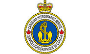
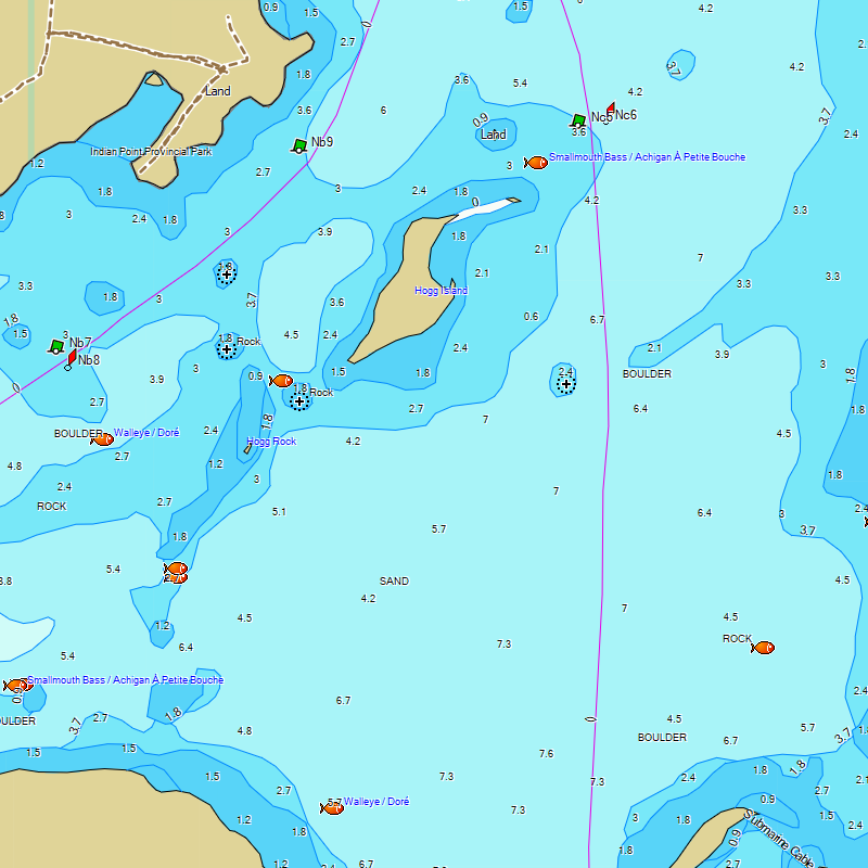
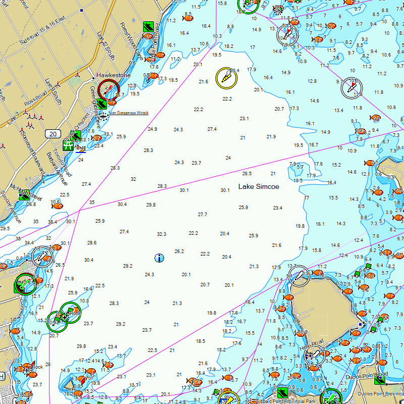
Description
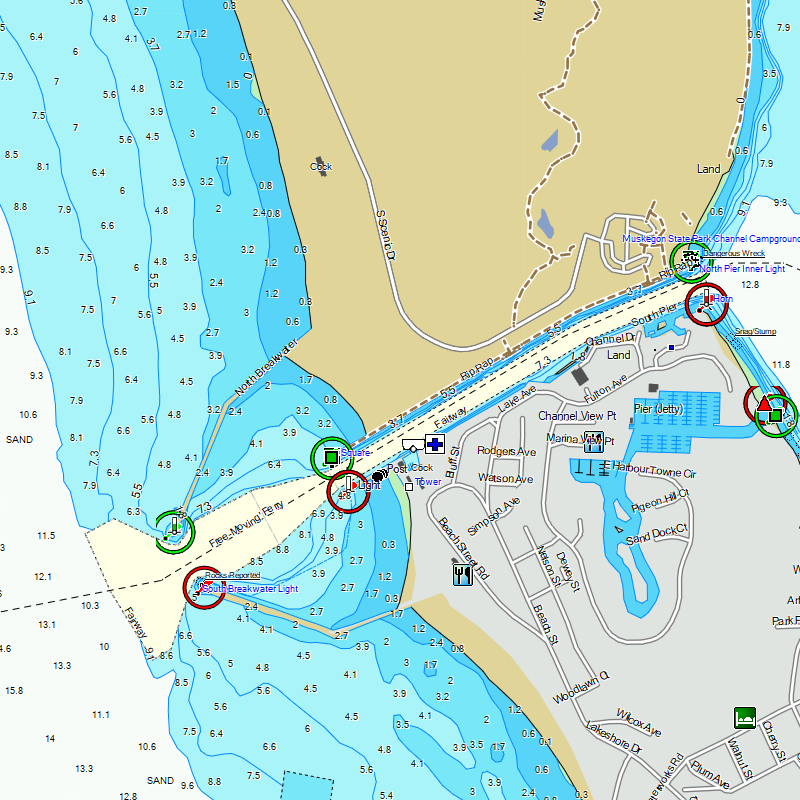
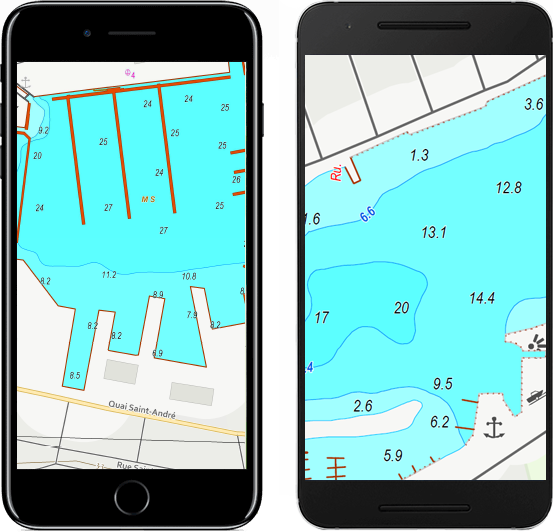
Que ça soit la plaisance, la pêche ou la pêche blanche, Marine Ontario pour GPS Garmin vous fournit les profondeurs et informations les plus récentes de voies navigables, lacs et rivières en Ontario.
Naviguez en toute sécurité sur l'eau avec profondeurs, contours, points d'intérêt et beaucoup plus!
Dernière mise à jour: 2025-01-19 Voir journal des modifications
Échelle: Variées
Taille du produit: 280 Mo+
Sources: Service hydrographique du Canada, Ministère des Richesses naturelles et des Forêts de l'Ontario, National Oceanic and Atmospheric Administration, TrakMaps
Couverture
Votre plan d'eau manque?
Plan d'eau inclus
Plan d'eau | Région |
|---|
Plan d'eau | Région |
|---|---|
| Abamategwia | ON |
| Abitibi - Garmin only/seulement | QC/ON |
| Abram | ON |
| Agimak | ON |
| Ahmic | ON |
| Albanel | QC |
| Alexandra | ON |
| Allard (bassin central) | QC |
| Allard (bassin nord) | QC |
| Allard (bassin sud) | QC |
| Alphonse | QC |
| Anima Nipissing (River) | ON |
| Anishinabi | ON |
| Anne | QC |
| Archambault | QC |
| Argent | QC |
| Ariel | QC |
| aux Dorés | QC |
| aux Sables (Réservoir) | QC |
| Aylen | ON |
| Aylmer | QC |
| Baie des Chaleurs (et sud jusqu’à Miramichi, NB) | QC |
| Balsam | ON |
| Baptiste | ON |
| Baribeau | QC |
| Barrière | QC |
| Barron | QC |
| Baskatong (Réservoir) | QC |
| Bay of Quinte | ON |
| Beauchamp | QC |
| Beauchêne | QC |
| Beaudry | QC |
| Beauharnois (Canal) | QC |
| Beaulac | QC |
| Beaulac | QC |
| Beaulne | QC |
| Beauport | QC |
| Beausoleil | QC |
| Becs-Scie (des) | QC |
| Bélair | QC |
| Bellevue | QC |
| Bennett | ON |
| Berens | ON |
| Bessette | QC |
| Bibite | QC |
| Big Gull | ON |
| Big Rideau | ON |
| Big Rideau | ON |
| Big Vermillion | ON |
| Bigelow | QC |
| Bixley | QC |
| Black | ON |
| Black | QC |
| Black Donald | ON |
| Black Sturgeon | ON |
| Blanc | QC |
| Blanche (de la) | QC |
| Bleu | QC |
| Blue Sea | QC |
| Bobs | ON |
| Boileau | QC |
| Boisrobert | QC |
| Borden | ON |
| Boshkung | ON |
| Boucané | QC |
| Bouchette | QC |
| Bourbeau | QC |
| Bowker | QC |
| Boyd | QC |
| Boyd | QC |
| Breton | QC |
| Brewer | QC |
| Brissette (à) | QC |
| Brochet (du) | QC |
| Brome | QC |
| Brompton | QC |
| Brompton (Petit) | QC |
| Bryson | QC |
| Buckhorn | ON |
| Buri | QC |
| Burrows | ON |
| Butler | QC |
| Cabane (de la) | QC |
| Cabonga (Réservoir) | QC |
| Caille (à la) | QC |
| Cain | ON |
| Calabogie | ON |
| Cameron | ON |
| Canard | QC |
| Canardière (de la) | QC |
| Cardin | QC |
| Carré | QC |
| Carrière | QC |
| Cartier | QC |
| Cavan | QC |
| Cayamant | QC |
| Cayuga-Seneca (Canal) | NY |
| Cecil | ON |
| Cedar | ON |
| Champlain | CA/US |
| Champlain (Canal) | QC |
| Chandos | ON |
| Chapleau | QC |
| Charleston | ON |
| Chats (des) | QC |
| Chaud | QC |
| Chemong | ON |
| Chevreuil | QC |
| Chevreuil | QC |
| Chibougamau | QC |
| Christie | ON |
| Clair | QC |
| Clair | QC |
| Clear | ON |
| Clearwater | ON |
| Clef (la) | QC |
| Clément | QC |
| Clovis | QC |
| Clyde | QC |
| Cobble | ON |
| Cœur (du) | QC |
| Colette | QC |
| Coli | ON |
| Colibri | QC |
| Côme-Lalande (des Frères) | QC |
| Confusion | ON |
| Connelly | QC |
| Cook | QC |
| Cornu | QC |
| Corriveau | QC |
| Couchiching | ON |
| Cranberry | ON |
| Creux | QC |
| Cristal | QC |
| Croche | QC |
| Croche | QC |
| Croche | QC |
| Croissant | QC |
| Cromwell | QC |
| Crow | ON |
| Cupidon | QC |
| Curran | QC |
| Dainava | QC |
| Daniels | ON |
| Dasserat | QC |
| David | QC |
| de l'Achigan | QC |
| Denis | QC |
| des Cèdres | QC |
| des Commissaires | QC |
| des Écorces | QC |
| des Grandes Baies | QC |
| des Îles | QC |
| des Mille | ON |
| des Mille-Îles (Rivière; ouest) | QC |
| des Outaouais (Rivière; Chats Falls - Britannia Bay; Ottawa - Carillon) | ON |
| des Piles | QC |
| des Plages | QC |
| des Prairies (Rivière) | QC |
| des Quinze | QC |
| des Sables | QC |
| des Seize Îles | QC |
| Désert (Frontenac) | QC |
| Désert (Laurentides) | QC |
| Desforges | QC |
| Desjardins | QC |
| Desmarais | QC |
| Detroit (River) | MI |
| Deux-Montagnes | QC |
| Dixon Entrance | BC |
| Dog | ON |
| Dozois (Réservoir) | QC |
| du Bras Coupé | QC |
| du Cerf (Grand) | QC |
| du Cerf (Petit) | QC |
| du Lièvre (Rivière) | QC |
| du Sourd | QC |
| Dudley | QC |
| Dufault | QC |
| Dufresne | QC |
| Duparquet | QC |
| Eagle | ON |
| Eagle | ON |
| Eagle (Frontenac Region) | ON |
| Écho | QC |
| Écho | QC |
| Écho | QC |
| Édouard | QC |
| Edward | ON |
| Elephant | ON |
| Équerre | QC |
| Erie | CA/US |
| Erie (Canal) | NY |
| Escalier (Réservoir) | QC |
| Esnagami | ON |
| Etchemin | QC |
| Eva | ON |
| Faillon | QC |
| Fairy | ON |
| Farmer | QC |
| Finlayson | ON |
| Forget | QC |
| Fortier | QC |
| Français | QC |
| Froid | QC |
| Fushimi | ON |
| Gaboury | QC |
| Gagnon | QC |
| Gagnon | QC |
| Galette | QC |
| Garry | QC |
| Gaspésie (Péninsule) | QC |
| Gatineau (River) | QC |
| Gatineau (Rivière) | QC |
| Geai | QC |
| Gélinas | QC |
| Gémont | QC |
| Georgia Sound | BC |
| Georgian Bay | ON |
| Gloucester Pool (Port Severn - Big Chute) | ON |
| Godon | QC |
| Goéland | QC |
| Golden | ON |
| Gordon | QC |
| Gouin (Réservoir) | QC |
| Grace | QC |
| Grand | QC |
| Grand Bostonnais | QC |
| Grand Lac St-François | QC |
| Granet | QC |
| Grange (de la) | QC |
| Green | QC |
| Greenwater | ON |
| Grenier | QC |
| Grothé | QC |
| Guindon | QC |
| Gulf Islands | BC |
| Gull | ON |
| Gull | ON |
| Gull Rock | ON |
| Gustave | QC |
| Haida Gwaii (Queen Charlotte Islands) | BC |
| Haie (de la) | QC |
| Haliburton | ON |
| Hall (River) | ON |
| Harrington | QC |
| Healey | ON |
| Hecate Strait | BC |
| Heney | QC |
| Holland (River) | ON |
| Houdet | QC |
| Huard | QC |
| Hudson (River; Champlain Canal - NYC, NY) | NY |
| Hughes | QC |
| Huron | ON |
| Île (à l') | QC |
| Île d'Antocosti | QC |
| Îles de la Madeleine | QC |
| Indian | ON |
| Indian (Eastern Region) | ON |
| Indien | QC |
| Inside Passage | BC |
| Ivanhoe | ON |
| Jack | ON |
| Jean-Péré | QC |
| Johanne | QC |
| Johnstone Strait | BC |
| Joinville | QC |
| Joly | QC |
| Joseph | ON |
| Joseph | QC |
| Joyce | QC |
| Juan de Fuca Strait | BC |
| Kabinakagami | ON |
| Kagawong | ON |
| Kahshe | ON |
| Kamaniskeg | ON |
| Kanawana | QC |
| Kapikog | ON |
| Kashagawigamog | ON |
| Kawagama | ON |
| Keg | ON |
| Kempt (Réservoir) | QC |
| Kennisis | ON |
| Kenny | QC |
| Kenogami | QC |
| Kenogamisis | ON |
| Kiamika | QC |
| Kimball | ON |
| Kipawa | QC |
| Kirkness | ON |
| Kukukus | ON |
| L'Heureux | QC |
| La Fantaisie | QC |
| La Motte | QC |
| La Salle | QC |
| Labelle | QC |
| Lac des Mille Lacs | ON |
| Lac Seul | ON |
| Lacasse | QC |
| Lachine (Canal) | QC |
| Lacoste | QC |
| Lady Evelyn | ON |
| Lamoureux | QC |
| Lanthier | QC |
| Laurel | QC |
| Lavallée | QC |
| Lavigne | QC |
| Lefebvre | QC |
| Lemoine | QC |
| Léon | QC |
| Léonard | QC |
| Leroux | QC |
| Lise | QC |
| Little Abitibi | ON |
| Little Butler | ON |
| Little French (River) | ON |
| Loiselle | QC |
| Long | QC |
| Louisa | QC |
| Louise | QC |
| Lovering | QC |
| Lower Black Sturgeon | ON |
| Lower Manitou | ON |
| Lower Manitou | ON |
| Lower Paudash | ON |
| Lower Rideau | ON |
| Lower Rideau | ON |
| Ludger | QC |
| MacShane | QC |
| Magog | QC |
| Maillé | QC |
| Malartic | QC |
| Mameigwess | ON |
| Manitou | QC |
| Manitouwabing | ON |
| Manouane | QC |
| Marie-Lefranc | QC |
| Marmion | ON |
| Marois | QC |
| Mary | ON |
| Maskinongé | QC |
| Maskinongé (Chaudière-Appalaches) | QC |
| Maskinongé (Lanaudière) | QC |
| Massawippi | QC |
| Masson | QC |
| Matagami | QC |
| Matapédia | QC |
| Mazinaw | ON |
| McCaskill | QC |
| McGregor | QC |
| Mégantic | QC |
| Mekinac | QC |
| Melançon | QC |
| Memphrémagog | QC |
| Ménard | QC |
| Mercier | QC |
| Michigan | US |
| Mille Lacs | QC |
| Millette | QC |
| Millette | QC |
| Mindemoya | ON |
| Mine (de la) | QC |
| Minnitaki | ON |
| Mississippi | ON |
| Mistassini | QC |
| Mitchell | QC |
| Mitchell (Cambridge Lock - Balsam) | ON |
| Mitchinamecus (Réservoir) | QC |
| Mohawk | QC |
| Monaco | QC |
| Mondonac | QC |
| Montagne (de la) | QC |
| Montagne (de la) | QC |
| Montagne-Noire | QC |
| Montaubois | QC |
| Montigny | QC |
| Montjoie | QC |
| Morency | QC |
| Morin | QC |
| Mourier | QC |
| Munich | QC |
| Muskoka | ON |
| Nantel | QC |
| Napoléon | QC |
| Némiscau | QC |
| Newboro | ON |
| Niagara (River) | ON |
| Nipissing | ON |
| No Man | QC |
| Noir | QC |
| Noiret | QC |
| Nominingue | QC |
| Nominingue (Petit) | QC |
| North Channel | ON |
| Northern Light | ON |
| Notre-Dame | QC |
| O’Neil | QC |
| Obéron | QC |
| of Bays | ON |
| of the Woods | ON |
| Olga | QC |
| Onaping | ON |
| Oneida | NY |
| Ontario | CA/US |
| Opasatica | QC |
| Opémisca | QC |
| Opinicon | ON |
| Orford | QC |
| Oswego (Canal) | NY |
| Otonabee (River) | ON |
| Ottawa (River; Chats Falls - Britannia Bay; Ottawa to Carillon) | ON |
| Otty | ON |
| Ouareau | QC |
| Ouelette | QC |
| Ouescapi | QC |
| Ouimet | QC |
| Ours (aux) | QC |
| Papineau | QC |
| Papineau | QC |
| Paquet | QC |
| Paquin | QC |
| Parent | QC |
| Patrick | QC |
| Paudash | ON |
| Paul | QC |
| Pelican | ON |
| Pelletier | QC |
| Pémichangan | QC |
| Peninsula | ON |
| Pigeon | ON |
| Pike | ON |
| Pilon | QC |
| Pin Rouge (du) | QC |
| Pins (des) | QC |
| Pohénégamook | QC |
| Poisson Blanc | QC |
| Poissons (aux) | QC |
| Preissac | QC |
| Preston | QC |
| Puget Sound | BC |
| Purvis | QC |
| Quatre Saisons (des) | QC |
| Quenouille | QC |
| Rainbow | QC |
| Rainbow (Petit lac) | QC |
| Ray | QC |
| Red | ON |
| Redstone | ON |
| Rémi | QC |
| Rémigny | QC |
| Renaud | QC |
| Renaud | QC |
| René | QC |
| Rice | ON |
| Richelieu (Rivière) | QC |
| Rideau (Canal) | ON |
| Rideau (River) | ON |
| Ripousse (de la) | QC |
| Rochon | QC |
| Roddick | QC |
| Roger | QC |
| Roger | QC |
| Rond | QC |
| Rond | QC |
| Rond | QC |
| Rond | QC |
| Rond | QC |
| Rosseau | ON |
| Rossignol | QC |
| Rougeaud | QC |
| Round | ON |
| Sacacomie | QC |
| Saguenay (Rivière) sauf/except Alma-Shipshaw | QC |
| Saint-Amour | QC |
| Saint-Denis | QC |
| Saint-Francois-Xavier (est) | QC |
| Saint-Francois-Xavier (ouest) | QC |
| Saint-Joseph | QC |
| Saint-Joseph | QC |
| Saint-Louis | QC |
| Saint-Louis | QC |
| Saint-Michel | QC |
| Saint-Onge | QC |
| Saint-Sauveur | QC |
| Saint-Victor | QC |
| Sainte-Marie | QC |
| Sainte-Marie (est) | QC |
| Sainte-Marie (ouest) | QC |
| Sakami | QC |
| San Juan Islands | BC |
| Sand | ON |
| sans toponyme (nom local: des Pins) | QC |
| sans toponyme (nom local: Noir) | QC |
| Sarrazin | QC |
| Sauvage | QC |
| Sawin | QC |
| Schryer | QC |
| Scugog | ON |
| Scugog (River) | ON |
| Seigneurs (des) | QC |
| Severn (River; Big Chute - Couchiching) | ON |
| Sharbot | ON |
| Shebandowan | ON |
| Simard | QC |
| Simcoe | ON |
| Simon | QC |
| Six Mile | ON |
| Skeleton | ON |
| Sommets (des) | QC |
| Sparrow | ON |
| Squatec | QC |
| St-Augustin | QC |
| St-François | QC |
| St-Jean | QC |
| St-Joseph (Capital-Nationale) | QC |
| St-Joseph (Laurentides) | QC |
| St-Laurent (Fleuve; Kingston à Tadoussac) | QC |
| St-Laurent (Golfe; Côte-Nord - La Romaine) | QC |
| St-Louis | QC |
| St-Maurice (Rivière) | QC |
| St-Pierre | QC |
| St. Clair | ON |
| St. Clair (River) | ON |
| St. Lawrence (River; Kingston – St. Lawrence Gulf)) | ON |
| Ste-Marie | QC |
| Stoco | ON |
| Stony | ON |
| Strait of Georgia | BC |
| Stukely | QC |
| Sturgeon | ON |
| Sucrerie (de la) | QC |
| Sucreries (des) | QC |
| Supérieur | QC |
| Superior | ON |
| Suzanne | QC |
| Sylvère | QC |
| Taureau | QC |
| Tay (Canal) | ON |
| Tea | ON |
| Temagami | ON |
| Témiscamingue | QC |
| Témiscouata | QC |
| Théodore | QC |
| Three Mile | ON |
| Touladi | QC |
| Tracy | QC |
| Travers | QC |
| Tremblant | QC |
| Trent (River; Rice Lake - Trenton) | ON |
| Trent-Severn (Waterway) | ON |
| Trente et un milles | QC |
| Triton | QC |
| Trois-Frères (des) - bassin A | QC |
| Trois-Frères (des) - bassin B | QC |
| Trois-Frères (des) - bassin C | QC |
| Truite (à la) | QC |
| Truite (à la) | QC |
| Truite (à la) | QC |
| Turgeon | QC |
| Twelve Mile | ON |
| Upper Manitou | ON |
| Upper Rideau | ON |
| Vaillant | QC |
| Vancouver Island | BC |
| Verdure | QC |
| Vernon | ON |
| Vézeau | QC |
| Victoria | QC |
| Vingt Sous | QC |
| Violon | QC |
| Violon | QC |
| Violon | QC |
| Wabigoon | ON |
| Waconichi | QC |
| Waswanipi | QC |
| Wawang | ON |
| Wawang | ON |
| Wayagamac | QC |
| White | ON |
| White | ON |
| White (Northwest Region) | ON |
| Whitefish | ON |
| Whitney | ON |
| William | QC |
| Windigo | QC |
| Windish | QC |
| Winnetou | QC |
| Wolfe | ON |
| Wolsey | ON |
| Xavier | QC |
L'avantage TrakMaps
1 an de mises à jour incluses
Obtenez les mises à jour de votre carte avec TrakUpdate.
Économisez gros
Économisez 50% lorsque vous renouvelez pour une autre année.
1 an de support inclus
Support de première classe basé au Canada: clavardage et courriel.
Facile à utiliser
Installation et mises à jour faciles afin que vous puissiez tirer le plus de vos activités de plein air.
Affichez-la sur votre ordinateur
Affichez votre carte dans Garmin BaseCamp pour Windows ou Mac.
Disponible en tout temps
Même dans les endroits sans réception cellulaire.
Localisation en temps réel
Votre carte vous localisera en temps réel afin que vous ne vous perdiez pas.
Points d'intérêt
Des milliers de points d'intérêt pour vous aider à retrouver le chemin.
Waypoints, itinéraires et plus
Compatible avec vos waypoints, routes et tracés de vos voyages.
Changement d'appareil GPS facile
Transférez votre carte d'un appareil GPS compatible à l'autre. Non applicable aux téléchargements.
Compatibilité garantie
Nous essayons nos cartes avec la plupart des appareils GPS sur le marché.
Vous avez un produit concurrent?
Obtenez un rabais quand vous passez à TrakMaps. Certaines restrictions s'appliquent.
Légende
 Clothing Retail
 Golf Course
 Beach
Beach
 Buoy Mooring
 Iso Dgr Surface Rock
 Diving Area
 Iso Dgr Covered Obstruction
 Gas Station
 Ski Center
 Museum
 Utility
 Picnic Area
 Bar
Bar
 Bank
Bank
 Buoy Starboard Hand
 First Aid
 Lake
Lake
 Trail
Trail
 Pile
Pile
 Mile Marker
 Hotel
Hotel
 Spring
 Waterfall
 Buoy East Cardinal
 Boat Ramp
 Controlled Area
 Large City
 Ice Skating
 Bridge
 Light Undefined
 Basin
Basin
 Grocery Store
 Rapids
 Theme Park
 Buoy Safe Water
 Parking
 Campground
 Buoy Port Hand
 Daymark Green Square
 School
 Anchorage Berths
 Light North Mark
 Shopping Center
 Restaurant
 Library
 Landmark
 Light West Mark
 Auto Club
 Light South Mark
 Stream
 Airport
 Slope
Slope
 Tunnel
 Light Starboard Hand Mark
 Casino
 Movie Theater
 Iso Dgr Wreck
 Rock
Rock
 Light Isolated Danger
 Buoy West Cardinal
 Buoy Special Purpose
 Pharmacy
 Light Special Mark
 Services Business
 Sand Bar
 Fishing Spot
 Iso Dgr Obstruction
 Harbor
 Pillar
 Light East Mark
 Information
 Swimming Area
 Light Port Hand Mark
 Buoy North Cardinal
 Scenic Area
 Crossing
 Marine Location Text
 City 500K
 Buoy South Cardinal
 Iso Dgr Underwater Rock
 Communication Services
 Iso Dgr Dangerous Rock
 Tower
Tower
 Fire Dept
 Locale
 Marina
 General Store
 Dam
Dam
 Building
 Int Bathy Contour
 Bridge
 Roundabout
 Anchorage
 Alley
Alley
 Railroad
 Restr Prohibited
 Stream
 Principal Hwy
 Ramp
Ramp
 Residential
 Low Speed Ramp
 Collector
 Arterial
 Shoreline
 Isobath Depth 1
 Isobath Depth 2
 Isobath Depth 3
 Isobath Depth 4
 Isobath Depth 5
 Major Hwy
 Overhead Cable
 Isobath Intertidal Zone
 Ferry
Ferry
 Restr Restricted
 Pipeline
 Marine Misc Line
 Trail
Trail
 Unpaved Road
 Obstr Danger
 Bridge
 Lake 100Mi
 Anchorage
 Golf Course
 Tundra
 Airport
 Land Urban
 Urban Park
 Marina
 Restr Prohibited
 Land
Land
 Sports Complex
 Wetland
 Generic Manmade
 Isobath Depth 2
 River Lt 100Ft
 Isobath Depth 1
 Isobath Depth 3
 Isobath Depth 4
 Isobath Depth 5
 Restr Restricted
 Isobath Intertidal Zone
 Large City
 National Park
 Small Lake
 State Park
 Lake
Lake
 Obstr Danger
 Marine Misc Area
Cartes sur mesure mobiles et imprimées
Choisissez votre endroit et recevez votre carte sur votre appareil iOS ou Android.
Témoignages
Mises à jour de votre carte pour Garmin
Utilisez TrakUpdate pour obtenir les dernières mises à jour de votre carte.
Détendez-vous pendant que nous la mettons à jour!


Nos partenaires
Nous travaillons avec une grande variété d'associations, de fédérations, de ministères et d'entreprises pour vous offrir les meilleurs produits sur le marché.